IAC chart of KADU
 ADC chart of KADU
 Satellite view of KADU

ADC chart of KADU
Satellite view of KADU
Sorry, we have no imagery here.
Sorry, we have no imagery here.
Sorry, we have no imagery here.
Sorry, we have no imagery here.
Sorry, we have no imagery here.
Sorry, we have no imagery here.


KADU - Audubon County
Located in Audubon, United States
ICAO - ADU, IATA -
Data provided by AirmateGeneral information
Coordinates: N41°42'6" W94°55'14"
Elevation is 1287 feet MSL.
Magnetic variation is 04° East View others Airports in Iowa
Operational data
Special qualification required
Current time UTC: 02:02:26
Current local time:
Weather
METAR: KADU 040155Z AUTO 13007KT 10SM SCT020 BKN075 OVC110 11/07 A2956 RMK AO2 PWINO
Communications frequencies: [VIEW]
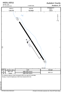
Runways:
| RWY identifier | QFU | Length (ft) | Width (ft) | Surface | LDA (ft) |
| 14 | 147° | 3641 | 60 | CONC | |
| 32 | 327° | 3641 | 60 | CONC |
Airport contact information
Address: Audubon United States
Satellite view of KADU
Sorry, we have no imagery here.
Sorry, we have no imagery here.
Sorry, we have no imagery here.
Sorry, we have no imagery here.
Sorry, we have no imagery here.
Sorry, we have no imagery here.