ADC chart of I27
 Satellite view of I27
Satellite view of I27
Sorry, we have no imagery here.
Sorry, we have no imagery here.
Sorry, we have no imagery here.
Sorry, we have no imagery here.
Sorry, we have no imagery here.
Sorry, we have no imagery here.


I27 - Elkader
Located in Elkader, United States
ICAO - I27, IATA -
Data provided by AirmateGeneral information
Coordinates: N42°50'50" W91°22'56"
Elevation is 932 feet MSL.
Magnetic variation is 02° East View others Airports in Iowa
Operational data
Special qualification required
Current time UTC: 02:14:28
Current local time:
Weather at : KPDC - Prairie Du Chien Muni ( 28 km )
METAR: KPDC 040155Z AUTO 12006KT 10SM OVC065 08/01 A2974 RMK AO2 T00820005
Communications frequencies: [VIEW]
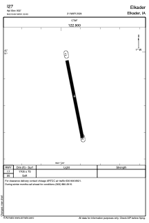
Runways:
| RWY identifier | QFU | Length (ft) | Width (ft) | Surface | LDA (ft) |
| 17 | 0° | 1705 | 75 | GRASS | |
| 35 | 0° | 1705 | 75 | GRASS |
Airport contact information
Address: Elkader United States
Satellite view of I27
Sorry, we have no imagery here.
Sorry, we have no imagery here.
Sorry, we have no imagery here.
Sorry, we have no imagery here.
Sorry, we have no imagery here.
Sorry, we have no imagery here.