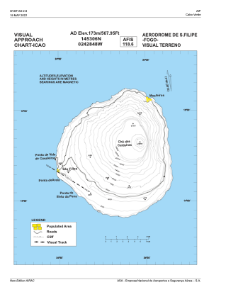
VAC chart of GVSF
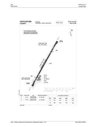
 ADC chart of GVSF
 Satellite view of GVSF

ADC chart of GVSF
Satellite view of GVSF
Sorry, we have no imagery here.
Sorry, we have no imagery here.
Sorry, we have no imagery here.
Sorry, we have no imagery here.
Sorry, we have no imagery here.
Sorry, we have no imagery here.


GVSF - Fogo Island/Sao Filipe
Located in Sao Filipe, Cape Verde
ICAO - GVSF, IATA - SFL
Data provided by AirmateGeneral information
Coordinates: N14°53'9" W24°28'52"
Elevation is 556 feet MSL.
View others Airports in Sotavento Islands
Operational data
Special qualification required
Current time UTC: 03:16:53
Current local time:
Weather at : - ( 0 km )
METAR: LEAL 230311Z VRB02KT 9999 -RA BKN067 17/15 Q1015 NOSIG
Communications frequencies: [VIEW]
Runways:
| RWY identifier | QFU | Length (ft) | Width (ft) | Surface | LDA (ft) |
| 14 | 130° | 4921 | 98 | UNK | |
| 32 | 310° | 4921 | 98 | UNK |
Airport contact information
Address: Sao Filipe Cape Verde
Satellite view of GVSF
Sorry, we have no imagery here.
Sorry, we have no imagery here.
Sorry, we have no imagery here.
Sorry, we have no imagery here.
Sorry, we have no imagery here.
Sorry, we have no imagery here.