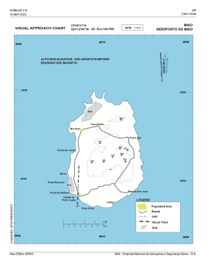
VAC chart of GVMA
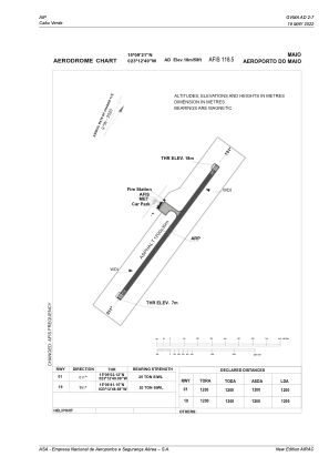
 ADC chart of GVMA
 Satellite view of GVMA

ADC chart of GVMA
Satellite view of GVMA
Sorry, we have no imagery here.
Sorry, we have no imagery here.
Sorry, we have no imagery here.
Sorry, we have no imagery here.
Sorry, we have no imagery here.
Sorry, we have no imagery here.


GVMA - Maio Island / Maio
Located in Barreiro, Cape Verde
ICAO - GVMA, IATA - MMO
Data provided by AirmateGeneral information
Coordinates: N15°9'21" W23°12'49"
Elevation is 60 feet MSL.
View others Airports in Sotavento Islands
Operational data
Special qualification required
Current time UTC: 07:19:35
Current local time:
Weather at : GVNP - Praia/Nelson Mandela ( 38 km )
METAR: GVNP 230700Z 04005KT 9999 FEW013 22/17 Q1014 NOSIG
TAF: TAF GVNP 230500Z 2306/2412 01014KT CAVOK
Communications frequencies: [VIEW]
Runways:
| RWY identifier | QFU | Length (ft) | Width (ft) | Surface | LDA (ft) |
| 01 | 2° | 3937 | 98 | UNK | |
| 19 | 182° | 3937 | 98 | UNK |
Airport contact information
Address: Barreiro Cape Verde
Satellite view of GVMA
Sorry, we have no imagery here.
Sorry, we have no imagery here.
Sorry, we have no imagery here.
Sorry, we have no imagery here.
Sorry, we have no imagery here.
Sorry, we have no imagery here.