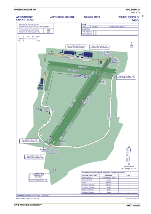
ADC chart of EGSG
 Satellite view of EGSG

Satellite view of EGSG
Sorry, we have no imagery here.
Sorry, we have no imagery here.
Sorry, we have no imagery here.
Sorry, we have no imagery here.
Sorry, we have no imagery here.
Sorry, we have no imagery here.


EGSG - Stapleford
Located in Romford, United Kingdom
ICAO - EGSG, IATA -
Data provided by AirmateGeneral information
Coordinates: N51°39'9" E0°9'22"
Elevation is 185 feet MSL.
View others Airports in England
Operational data
Special qualification required
Current time UTC: 12:42:22
Current local time:
Weather at : EGLC - London/City ( 18 km )
METAR: EGLC 261220Z AUTO 23012KT 9999 BKN025 BKN031 23/16 Q1010
TAF: TAF EGLC 261056Z 2612/2621 24011KT 9999 BKN020 PROB30 TEMPO 2612/2614 7000 RA -SHRA BECMG 2613/2615 CAVOK PROB30 TEMPO 2614/2617 25015G25KT
Communications frequencies: [VIEW]
Runways:
| RWY identifier | QFU | Length (ft) | Width (ft) | Surface | LDA (ft) |
| 03R | 36° | 3533 | 151 | UNK | |
| 21L | 216° | 3533 | 151 | UNK | |
| 03L | 35° | 2953 | 98 | UNK | |
| 21R | 216° | 2953 | 98 | UNK |
Airport contact information
Address: Romford United Kingdom
Other aviation service providers
Flight schools

Stapleford Flying Club Limited T/A Stapleford Flight Centre
Stapleford Flying Club Limited T/A Stapleford Flight Centre
lauraward@flysfc.com+44 01708688380