ADC chart of EGOV
 Satellite view of EGOV

Satellite view of EGOV
Sorry, we have no imagery here.
Sorry, we have no imagery here.
Sorry, we have no imagery here.
Sorry, we have no imagery here.
Sorry, we have no imagery here.
Sorry, we have no imagery here.


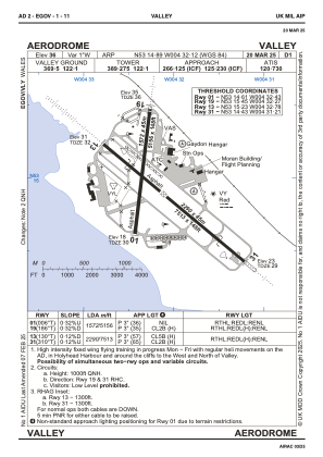
EGOV - Valley
Located in Rhosneigr, United Kingdom
ICAO - EGOV, IATA - VLY
Data provided by AirmateGeneral information
Coordinates: N53°14'53" W4°32'7"
Elevation is 36 feet MSL.
Magnetic variation is -2° East View others Airports in Wales
Operational data
Special qualification required
Current time UTC: 11:27:46
Current local time:
Weather
METAR: EGOV 301050Z 22013KT 9999 FEW002 15/13 Q1016 TEMPO SCT003 RMK BLU TEMPO YLO2
TAF: TAF EGOV 301053Z 3012/3018 22015KT 9999 FEW003 PROB30 TEMPO 3012/3015 3000 BR SCT003 PROB30 TEMPO 3015/3018 2000 BR BKN002
Communications frequencies: [VIEW]
Runways:
| RWY identifier | QFU | Length (ft) | Width (ft) | Surface | LDA (ft) |
| 01 | 6° | 5157 | 148 | ASPH | 5157 |
| 19 | 186° | 5157 | 148 | ASPH | 5157 |
| 13 | 130° | 7513 | 148 | ASPH | 7513 |
| 31 | 310° | 7513 | 148 | ASPH | 7513 |
Airport contact information
Address: Rhosneigr United Kingdom
Satellite view of EGOV
Sorry, we have no imagery here.
Sorry, we have no imagery here.
Sorry, we have no imagery here.
Sorry, we have no imagery here.
Sorry, we have no imagery here.
Sorry, we have no imagery here.