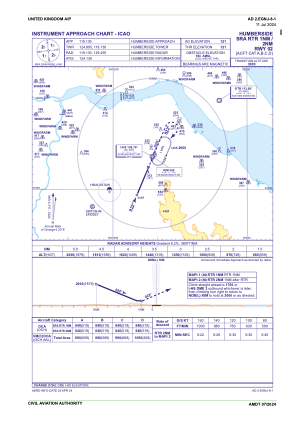
IAC chart of EGNJ
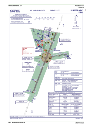
 ADC chart of EGNJ
 Satellite view of EGNJ

ADC chart of EGNJ
Satellite view of EGNJ
Sorry, we have no imagery here.
Sorry, we have no imagery here.
Sorry, we have no imagery here.
Sorry, we have no imagery here.
Sorry, we have no imagery here.
Sorry, we have no imagery here.


EGNJ - Humberside
Located in Hull, United Kingdom
ICAO - EGNJ, IATA - HUY
Data provided by AirmateGeneral information
Coordinates: N53°34'24" W0°21'5"
Elevation is 121 feet MSL.
View others Airports in England
Operational data
Special qualification required
Current time UTC: 13:11:06
Current local time:
Weather
METAR: EGNJ 041250Z 23022KT 9999 FEW035 25/08 Q1021
TAF: TAF EGNJ 041057Z 0412/0421 23015KT 9999 FEW030 PROB40 TEMPO 0412/0421 24018G28KT PROB30 TEMPO 0418/0421 8000 -RA
Communications frequencies: [VIEW]
Runways:
| RWY identifier | QFU | Length (ft) | Width (ft) | Surface | LDA (ft) |
| 02 | 22° | 7218 | 148 | UNK | |
| 20 | 202° | 7218 | 148 | UNK | |
| 08 | 82° | 3248 | 59 | UNK | |
| 26 | 262° | 3248 | 59 | UNK |
Airport contact information
Address: Hull United Kingdom

