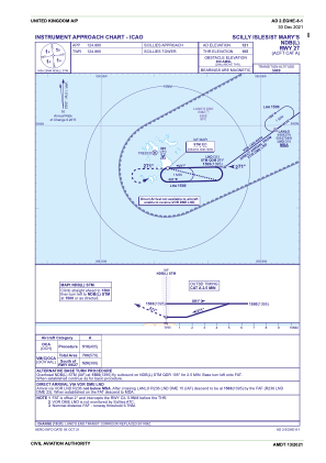
IAC chart of EGHE
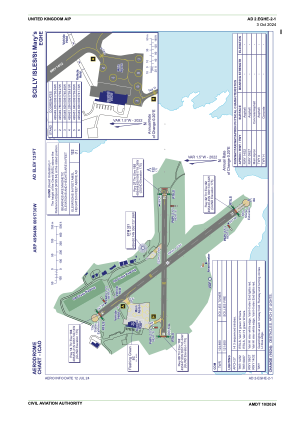
 ADC chart of EGHE
 Satellite view of EGHE

ADC chart of EGHE
Satellite view of EGHE
Sorry, we have no imagery here.
Sorry, we have no imagery here.
Sorry, we have no imagery here.
Sorry, we have no imagery here.
Sorry, we have no imagery here.
Sorry, we have no imagery here.


EGHE - Scilly Isles/St Mary's
Located in Hugh Town, United Kingdom
ICAO - EGHE, IATA - ISC
Data provided by AirmateGeneral information
Coordinates: N49°54'48" W6°17'30"
Elevation is 121 feet MSL.
View others Airports in England
Operational data
Special qualification required
Current time UTC: 11:56:44
Current local time:
Weather
METAR: EGHE 271150Z 22017KT 9999 BKN009 20/17 Q1020
TAF: TAF EGHE 271057Z 2712/2718 22014KT 9999 SCT015 PROB30 TEMPO 2712/2718 22018G28KT PROB30 TEMPO 2712/2713 BKN008 TEMPO 2713/2718 BKN006 PROB30 TEMPO 2714/2718 6000 -RADZ
Communications frequencies: [VIEW]
Runways:
| RWY identifier | QFU | Length (ft) | Width (ft) | Surface | LDA (ft) |
| 14 | 139° | 2123 | 75 | asphalt | |
| 32 | 319° | 2123 | 75 | asphalt | |
| 09 | 87° | 1713 | 59 | Grass/Asphalt | |
| 27 | 267° | 1713 | 59 | Grass/Asphalt |
Airport contact information
Address: Hugh Town United Kingdom
Satellite view of EGHE
Sorry, we have no imagery here.
Sorry, we have no imagery here.
Sorry, we have no imagery here.
Sorry, we have no imagery here.
Sorry, we have no imagery here.
Sorry, we have no imagery here.