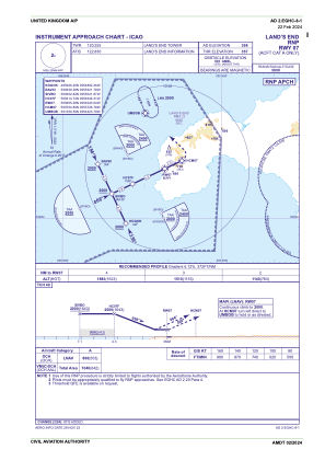
IAC chart of EGHC
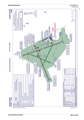
 ADC chart of EGHC
 Satellite view of EGHC

ADC chart of EGHC
Satellite view of EGHC
Sorry, we have no imagery here.
Sorry, we have no imagery here.
Sorry, we have no imagery here.
Sorry, we have no imagery here.
Sorry, we have no imagery here.
Sorry, we have no imagery here.


EGHC - Land's End
Located in Penzance, United Kingdom
ICAO - EGHC, IATA - LEQ
Data provided by AirmateGeneral information
Coordinates: N50°6'10" W5°40'14"
Elevation is 398 feet MSL.
View others Airports in England
Operational data
Special qualification required
Current time UTC: 09:31:00
Current local time:
Weather
TAF: TAF EGHC 040759Z 0409/0418 28006KT 9999 FEW035
Communications frequencies: [VIEW]
Runways:
| RWY identifier | QFU | Length (ft) | Width (ft) | Surface | LDA (ft) |
| 02 | 20° | 1585 | 62 | Grass | |
| 20 | 200° | 1585 | 62 | Grass | |
| 07 | 65° | 2274 | 59 | Grass | |
| 25 | 245° | 2274 | 59 | Grass | |
| 16 | 158° | 2572 | 59 | Grass | |
| 34 | 338° | 2572 | 59 | Grass | |
| 11 | 113° | 1568 | 59 | UNK | |
| 29 | 293° | 1568 | 59 | UNK |
Airport contact information
Address: Penzance United Kingdom
Satellite view of EGHC
Sorry, we have no imagery here.
Sorry, we have no imagery here.
Sorry, we have no imagery here.
Sorry, we have no imagery here.
Sorry, we have no imagery here.
Sorry, we have no imagery here.