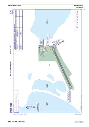
ADC chart of EGED
 Satellite view of EGED

Satellite view of EGED
Sorry, we have no imagery here.
Sorry, we have no imagery here.
Sorry, we have no imagery here.
Sorry, we have no imagery here.
Sorry, we have no imagery here.
Sorry, we have no imagery here.


EGED - Eday
Located in Eday Island, United Kingdom
ICAO - EGED, IATA - EOI
Data provided by AirmateGeneral information
Coordinates: N59°11'25" W2°46'21"
Elevation is 13 feet MSL.
Magnetic variation is -1° East View others Airports in Scotland
Operational data
Special qualification required
Current time UTC: 09:33:43
Current local time:
Weather at : EGPA - Kirkwall ( 27 km )
METAR: EGPA 290920Z 12013KT 9000 RADZ BKN008 BKN040 10/09 Q1002
TAF: TAF EGPA 290758Z 2909/2918 14012KT 9999 SCT010 BKN020 TEMPO 2909/2912 4000 RA BKN010 PROB40 TEMPO 2909/2915 BKN004 PROB30 TEMPO 2909/2912 2000 +RA RADZ BECMG 2912/2915 28012KT PROB30 TEMPO 2916/2918 29015G25KT
Communications frequencies: [VIEW]
Runways:
| RWY identifier | QFU | Length (ft) | Width (ft) | Surface | LDA (ft) |
| 07 | 64° | 1729 | 59 | Graded Hardcore | |
| 25 | 244° | 1729 | 59 | Graded Hardcore |
Airport contact information
Address: Eday Island United Kingdom
Satellite view of EGED
Sorry, we have no imagery here.
Sorry, we have no imagery here.
Sorry, we have no imagery here.
Sorry, we have no imagery here.
Sorry, we have no imagery here.
Sorry, we have no imagery here.