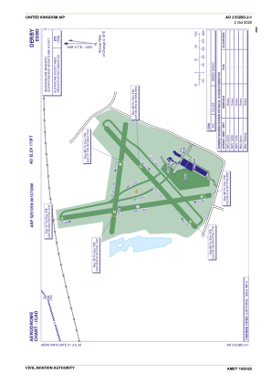
ADC chart of EGBD
 Satellite view of EGBD

Satellite view of EGBD
Sorry, we have no imagery here.
Sorry, we have no imagery here.
Sorry, we have no imagery here.
Sorry, we have no imagery here.
Sorry, we have no imagery here.
Sorry, we have no imagery here.


EGBD - Derby
Located in Derby, United Kingdom
ICAO - EGBD, IATA -
Data provided by AirmateGeneral information
Coordinates: N52°51'35" W1°37'3"
Elevation is 175 feet MSL.
View others Airports in England
Operational data
Special qualification required
Current time UTC: 08:12:50
Current local time:
Weather at : EGNX - East Midlands ( 20 km )
TAF: TAF EGNX 060454Z 0606/0706 23012KT 9999 SCT045 TEMPO 0606/0610 6000 RA SHRA BKN012 PROB40 TEMPO 0606/0610 3000 +TSRA BKN009 BKN020CB BECMG 0608/0611 31014KT PROB30 TEMPO 0610/0614 31017G27KT 3000 +TSRA BKN014 BKN020CB TEMPO 0623/0706 BKN012 PROB30 TEMPO 0623/0705 6000 RA SHRA BKN008
Communications frequencies: [VIEW]
Runways:
| RWY identifier | QFU | Length (ft) | Width (ft) | Surface | LDA (ft) |
| 05 | 48° | 1795 | 66 | Grass | |
| 23 | 228° | 1795 | 66 | Grass | |
| 10 | 98° | 1486 | 66 | Grass | |
| 28 | 278° | 1486 | 66 | Grass | |
| 17 | 171° | 1949 | 66 | Grass | |
| 35 | 351° | 1949 | 66 | Grass |
Airport contact information
Address: Derby United Kingdom
Other aviation service providers
Flight schools

Airspeed Aviation Limited T/A Derby Aero Club & Flying School
Airspeed Aviation Limited T/A Derby Aero Club & Flying School
derbyaeroclub@btconnect.com+44 01283733803