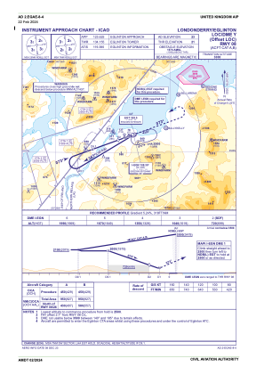
IAC chart of EGAE
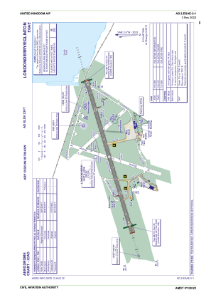
 ADC chart of EGAE
 Satellite view of EGAE

ADC chart of EGAE
Satellite view of EGAE
Sorry, we have no imagery here.
Sorry, we have no imagery here.
Sorry, we have no imagery here.
Sorry, we have no imagery here.
Sorry, we have no imagery here.
Sorry, we have no imagery here.


EGAE - Londonderry/Eglinton
Located in Londonderry, United Kingdom
ICAO - EGAE, IATA - LDY
Data provided by AirmateGeneral information
Coordinates: N55°2'34" W7°9'43"
Elevation is 23 feet MSL.
View others Airports in Northern Ireland
Operational data
Special qualification required
Current time UTC: 21:22:12
Current local time:
Weather
METAR: EGAE 302050Z 05007KT 9999 SCT035 15/12 Q1013
TAF: TAF EGAE 301702Z 3018/3022 25006KT 9999 FEW018 SCT030 BECMG 3018/3020 07010KT PROB30 TEMPO 3018/3022 7000 SHRA BECMG 3020/3022 22005KT
Communications frequencies: [VIEW]
Runways:
| RWY identifier | QFU | Length (ft) | Width (ft) | Surface | LDA (ft) |
| 08 | 73° | 6460 | 148 | ASP | |
| 26 | 253° | 6460 | 148 | ASP |
Airport contact information
Address: Londonderry United Kingdom

