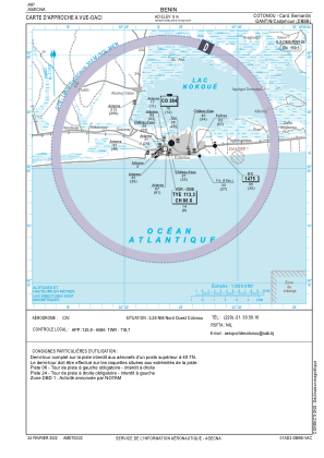
VAC chart of DBBB
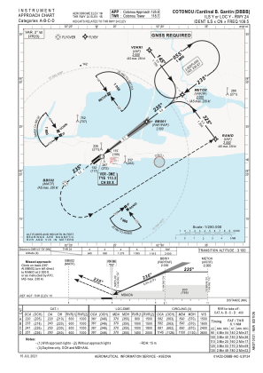
 IAC chart of DBBB
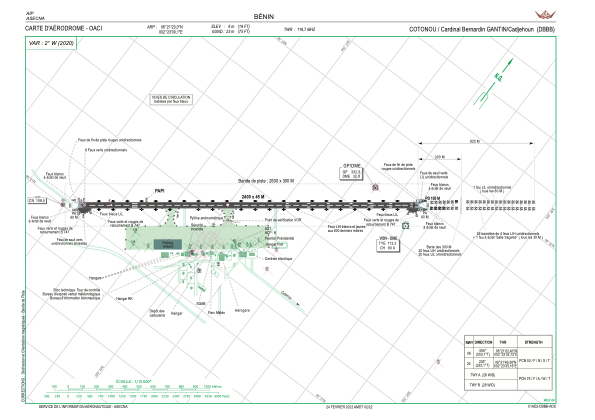
 ADC chart of DBBB
 Satellite view of DBBB

IAC chart of DBBBADC chart of DBBB
Satellite view of DBBB
Sorry, we have no imagery here.
Sorry, we have no imagery here.
Sorry, we have no imagery here.
Sorry, we have no imagery here.
Sorry, we have no imagery here.
Sorry, we have no imagery here.


DBBB - Aeroport International Cardinal Bernardin Gantin / Cadjehoun
Located in Cotonou, Benin
ICAO - DBBB, IATA - COO
Data provided by AirmateGeneral information
Coordinates: N6°21'23" E2°23'0"
Elevation is 20 feet MSL.
View others Airports in Atlantique
Operational data
Special qualification required
Current time UTC: 13:36:38
Current local time:
Weather
METAR: DBBB 231300Z 23011KT 190V260 9999 SCT012 32/25 Q1011 NOSIG
TAF: TAF COR DBBB 231100Z 2312/2418 23011KT 9999 BKN011 FEW022CB PROB30 TEMPO 2312/2318 13015G25KT 3500 TSRA BECMG 2318/2320 SCT012
Communications frequencies: [VIEW]
Runways:
| RWY identifier | QFU | Length (ft) | Width (ft) | Surface | LDA (ft) |
| 06 | 53° | 7874 | 148 | ASP | |
| 24 | 233° | 7874 | 148 | ASP |
Airport contact information
Address: Cotonou Benin
Satellite view of DBBB
Sorry, we have no imagery here.
Sorry, we have no imagery here.
Sorry, we have no imagery here.
Sorry, we have no imagery here.
Sorry, we have no imagery here.
Sorry, we have no imagery here.