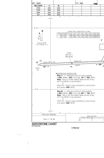
ADC chart of CYMH
 Satellite view of CYMH

Satellite view of CYMH
Sorry, we have no imagery here.
Sorry, we have no imagery here.
Sorry, we have no imagery here.
Sorry, we have no imagery here.
Sorry, we have no imagery here.
Sorry, we have no imagery here.


CYMH - Marys Harbour
Located in , Canada
ICAO - CYMH, IATA - YMH
Data provided by AirmateGeneral information
Coordinates: N52°18'10" W55°50'52"
Elevation is 35 feet MSL.
Magnetic variation is -18.8702° East View others Airports in Newfoundland and Labrador
Operational data
Special qualification required
Current time UTC: 19:12:55
Current local time:
Weather
TAF: TAF CYMH 141340Z 1414/1502 20012G22KT P6SM BKN030 TEMPO 1414/1419 BKN020 FM141900 20012G22KT P6SM SCT020 BKN040 TEMPO 1419/1502 P6SM -SHRA BKN020 OVC040 PROB30 1500/1502 VRB20G30KT 3SM TSRA BR OVC020CB RMK FCST BASED ON AUTO OBS. NXT FCST BY 142000Z
Communications frequencies: [VIEW]
Runways:
| RWY identifier | QFU | Length (ft) | Width (ft) | Surface | LDA (ft) |
| 11 | 88° | 2545 | 75 | GRAVE | 2545 |
| 29 | 268° | 2545 | 75 | GRAVE | 2545 |
Airport contact information
Address: Canada
Satellite view of CYMH
Sorry, we have no imagery here.
Sorry, we have no imagery here.
Sorry, we have no imagery here.
Sorry, we have no imagery here.
Sorry, we have no imagery here.
Sorry, we have no imagery here.