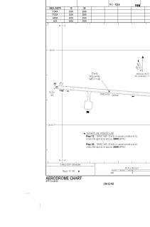
ADC chart of CNH2
 Satellite view of CNH2

Satellite view of CNH2
Sorry, we have no imagery here.
Sorry, we have no imagery here.
Sorry, we have no imagery here.
Sorry, we have no imagery here.
Sorry, we have no imagery here.
Sorry, we have no imagery here.


CNH2 - Natuashish
Located in , Canada
ICAO - CNH2, IATA -
Data provided by AirmateGeneral information
Coordinates: N55°54'50" W61°11'4"
Elevation is 33 feet MSL.
Magnetic variation is -21.3343° East View others Airports in Newfoundland and Labrador
Operational data
Special qualification required
Current time UTC: 21:52:19
Current local time:
Weather at : CYDP - Nain ( 77 km )
METAR: CYDP 182100Z 34023G31KT 15SM SCT210 BKN230 M01/M04 A2954 RMK CC3CS2 SLP006
TAF: TAF CYDP 181940Z 1820/1824 31025G35KT P6SM SCT200 RMK NXT FCST BY 191100Z
Communications frequencies: [VIEW]
Runways:
| RWY identifier | QFU | Length (ft) | Width (ft) | Surface | LDA (ft) |
| 12 | 95° | 2500 | 75 | GRAVE | 2500 |
| 30 | 275° | 2500 | 75 | GRAVE | 2500 |
Airport contact information
Address: Canada
Satellite view of CNH2
Sorry, we have no imagery here.
Sorry, we have no imagery here.
Sorry, we have no imagery here.
Sorry, we have no imagery here.
Sorry, we have no imagery here.
Sorry, we have no imagery here.