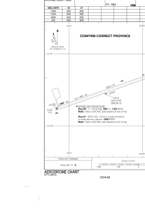
ADC chart of CCH4
 Satellite view of CCH4
Satellite view of CCH4
Sorry, we have no imagery here.
Sorry, we have no imagery here.
Sorry, we have no imagery here.
Sorry, we have no imagery here.
Sorry, we have no imagery here.
Sorry, we have no imagery here.


CCH4 - Charlottetown
Located in , Canada
ICAO - CCH4, IATA - YHG
Data provided by AirmateGeneral information
Coordinates: N52°45'57" W56°6'45"
Elevation is 210 feet MSL.
Magnetic variation is -19.0829° East View others Airports in Newfoundland and Labrador
Operational data
Special qualification required
Current time UTC: 21:50:17
Current local time:
Weather at : CYMH - Marys Harbour ( 54 km )
METAR: CYMH 182139Z AUTO 36016G28KT 2 1/4SM -RA BR BKN005 OVC012 01/01 A2901 RMK PCPN 0.8MM PAST HR SLP827
TAF: TAF CYMH 181942Z 1820/1904 01018G35KT 1 1/2SM -RASN BR OVC008 TEMPO 1820/1824 3SM BR SCT008 OVC012 FM190000 01015G28KT 1 1/2SM -SNRA BR OVC005 TEMPO 1900/1904 3SM BR OVC007 RMK FCST BASED ON AUTO OBS. NXT FCST BY 190200Z
Communications frequencies: [VIEW]
Runways:
| RWY identifier | QFU | Length (ft) | Width (ft) | Surface | LDA (ft) |
| 09 | 70° | 2502 | 75 | GRAVE | 2502 |
| 27 | 250° | 2502 | 75 | GRAVE | 2502 |
Airport contact information
Address: Canada
