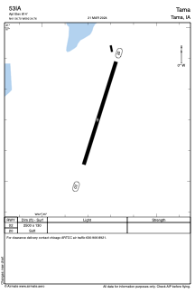
ADC chart of 53IA
 Satellite view of 53IA

Satellite view of 53IA
Sorry, we have no imagery here.
Sorry, we have no imagery here.
Sorry, we have no imagery here.
Sorry, we have no imagery here.
Sorry, we have no imagery here.
Sorry, we have no imagery here.


53IA - Tama
Located in Tama, United States
ICAO - 53IA, IATA -
Data provided by AirmateGeneral information
Coordinates: N41°56'42" W92°34'45"
Elevation is 814 feet MSL.
Magnetic variation is 03° East View others Airports in Iowa
Operational data
Special qualification required
Current time UTC: 02:12:15
Current local time:
Weather at : KGGI - Grinnell Rgnl ( 29 km )
METAR: KGGI 040155Z AUTO 13008KT 10SM OVC048 13/04 A2968 RMK AO2 T01280041
Communications frequencies: [VIEW]
Runways:
| RWY identifier | QFU | Length (ft) | Width (ft) | Surface | LDA (ft) |
| 02 | 18° | 2500 | 130 | GRASS | |
| 20 | 198° | 2500 | 130 | GRASS |
Airport contact information
Address: Tama United States
Satellite view of 53IA
Sorry, we have no imagery here.
Sorry, we have no imagery here.
Sorry, we have no imagery here.
Sorry, we have no imagery here.
Sorry, we have no imagery here.
Sorry, we have no imagery here.